
De-prioritizing cars in the transportation hierarchy

When cars are driven by programs not people, how will people on the street communicate with cars? At CES 2019, leading mobility manufacturers like Ford shared advancements in Vehicle-to-Everything platforms that use electronic pings from pedestrians’ smart devices to help guide autonomous vehicles (AV). But solutions like these are too narrow and don’t respect the autonomy of individuals—not everyone has a smart device or wishes to be involuntarily or constantly connected to everything. We should be cautious of any framework that re-enforces cars at the top of the transportation hierarchy and fails to take a more comprehensive view of our future streets.
“It’s an unreasonable burden to ask or require people walking in their streets and cities and in front of their homes to carry a signal transmitting device.”
— Corinne Kisner, Deputy Director of the National Association of City Transportation Officials
The last century was all about designing cities around the needs of cars. But today, many cities have committed to reducing or entirely removing cars from pedestrian-heavy areas and have set ambitious goals to become carbon neutral in the coming decades. Recent research shows that while swapping individual ownership for more self-driving cars could improve transportation times, it could also worsen congestion. So in readying our cities for AV, we need to plan for a mix of mobility types: pedestrians, cyclists, scooters, public transit, and more.
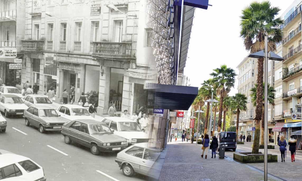
Calle Mellado in Pontevedra, before and after restricting cars. (Photo: Concello de Pontevedra, 2018)
Here are a few cities prioritizing multiple transportation modes.
Pontevedra, Spain: Mayor Miguel Lores says his philosophy is simple: “owning a car doesn’t give you the right to occupy the public space.” Pontevedra has pedestrianized all 300,000 square meters of the city center, reduced car-related deaths by 100%, and brought CO2 emissions down by 70%. Nearly three-quarters of journeys previously taken in cars are now made on foot or bicycle.
Stockholm, Sweden: New proposals sponsored by Stockholm Transit Commissioner slash available car space in the city’s streets and open up a large chunk of its waterfront as a pedestrian-friendly promenade. Plans to extend pedestrian streets, improve bike lanes, and trim road space in order to de-prioritize cars in favor of boosting pedestrians and cyclists are already underway.
Oslo, Norway: Oslo has grown faster than nearly any other city in Europe. Plans to combat congestion include replacing hundreds of parking spaces with 60 kilometers of new bike lanes and pocket parks, creating a car-free and people-oriented city center.

Research by Nicolas Palominos applies an algorithm to analyze pedestrian spaces within 200,000 cross-sections of London streets.
We also need more diverse data.
Truly intelligent solutions start with diversifying their data points and sources to plan shared streets beyond official city and vendor-sourced data. Leveraging more informal, crowd-sourced inputs from individuals and communities are giving city planners a more nuanced perspective on persistent problems:
Traffic-oriented planning has resulted in disproportionate space allocated to cars. To counteract this trend, Nicolas Palominos, researcher at The Bartlett Center for Spatial Analysis, built a geo-computation tool (a series of algorithms) that processes data from 200,000 cross-sections of London’s streets to quantify how road space is distributed between pedestrians and vehicles.
To broaden the view of blocked bike lanes in NYC beyond the City’s 311 reports, Stae collaborated with Bits & Atoms to scrape thousands of tweets of freight and service vehicles in order to identify street and neighborhood-level patterns.
To expand the possibilities of how streets are used, dérive LAB, an urban laboratory based in Latin America, has created a set of guides for community members and decision makers to test new ways of sharing and programming streets.

A set of guides by dérive LAB for anyone to envision and design shared streets.
The rise of AV can play a crucial role in future city design. But we need to approach hard problems with holistic perspectives. Continuing to over-focus on cars without considering the diverse needs of cities (and most importantly the people who move through them every day) will lead to creating spaces where the technology improves, but the quality of life for local residents does not.